The plan was to wake up a couple hours before sunrise and hit the trail with headlamps, arriving at the valley of The Wave before first light on the brilliantly colored west wall.
But it was 14 degrees when we awoke!!!
So we stayed in our snuggly, warm sleeping bags for a couple hours more. Not that the temperature got any warmer during that time...
As it turned out, the sun didn't come up that day, at least not at The Wave. A thick bank of clouds blocked it for a good four or five hours, but that also meant we didn't have to deal with harsh shadows while photographing paradise.

We were the first hikers in the Wire Pass Trailhead parking lot, and although another vehicle arrived before we hit the trail, we were first on the trail. We didn't get far, though, before the second couple, hailing from Australia, called out from the parking lot, asking if we were going to The Wave.
The Aussie accent is so delightful, we couldn't help but share the first two-thirds of the journey with them. Tales of their five-week journey across America (ending the following week with a tour of Yosemite before heading back home) captivated us so thoroughly, we'd traversed a full two miles before the air became quiet.
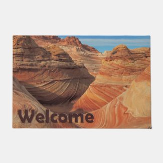
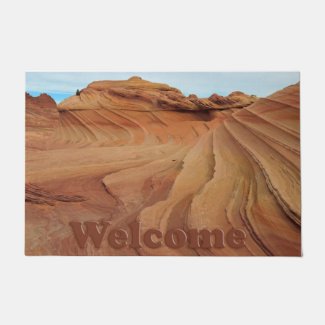
Ahead, we could see "the notch," the deep crack in a canyon wall directly above The Wave and the best visual the BLM provides to permit holders. We were almost there!

The goal, at least for me, had been to ring the valley, shooting the sunrise (which, of course, didn't happen) while searching for dinosaur footprints below "the pink band," before crossing the sage flats to look for The Wave II. We hadn't had time to explore during our first, impromptu trip, but this time, we had all day. I wanted to see everything. I wanted to shoot everything.
The Lizard and the Aussies reached the base of the sand dune which must be scaled to enter The Wave by the time I reached the edge of the west valley wall. I'd fallen seriously behind because I just couldn't stop taking pictures! I didn't know if The Lizard would wait for me at The Wave or make his way back across the flats to join me, but I knew he could see the neon band of lime green on my fleece sweater as well as I could make him out all the way across the valley, so I began searching for dinosaur imprints along the base of the upper pink band.
I was successful in my search, but I didn't shoot any tracks until after I heard a familiar voice from behind. The Lizard had joined me! Together we searched both the upper and lower pink bands and found a good many tracks, but I shot only one set. There were too many other things to photograph!

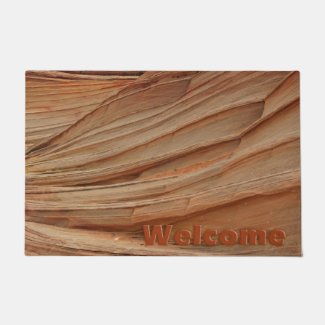
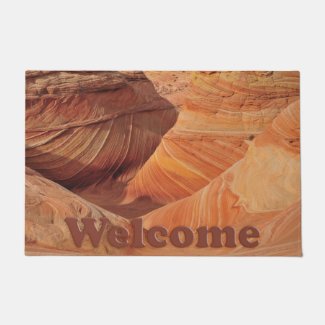
The rock formations were amazing, and I'd never seen photos from this side of the valley. Hikers are always so intent on The Wave, they don't often explore what other mysteries Coyote Buttes holds.
We reached a confluence of the two pink bands where they dropped off the edge of a high cliff. We ascended a red rock wall to see what was up above. More wonderful rock formations and sandstone coloring!
From this high vantage point, we could see a frozen waterfall at the end of the valley. So, of course, we had to get closer. En route, we often were the only recent footprints in the sand beds we followed. The rock formations just kept getting better and better. I wanted to spend a whole week here! I wondered which of three cameras I'd toted along would run out of battery juice first. And which one would need a new memory card first???

The Nikon D300, my "big gun," won that race. Fortunately, I'd charged all the cameras via the 4Runner's cigarette lighter the night before in camp, and I never ran out of power, although I did have spare charged batteries for two of the cameras.
At one high point along the way, my iPhone sang out that I'd received an email. In the middle of nowhere!!! I knew better than to check. It lies. When I briefly logged into the phone, it promptly informed me it could not retrieve email because no internet connection was available. No kidding!
The frozen waterfall wasn't as spectacular as it looked from afar. It was more of a melting snow seep than a waterfall, and in total permanent shade (which is how the ice formed in the first place), getting a good shot wasn't easy. We began traversing the cliffs back toward The Wave.

Again, the rock formations and colors were so fascinating, they rivaled anything we'd already seen. We marveled that few ever venture where we were but lamented the loss of pristine adventurism once my photos garner wide audience. When others see the unknown secrets buried outside The Wave proper, there will be no solitude and no more mysteries.
Maybe I shouldn't share ALL my photos...
Finally, The Lizard interrupted my 70th or so sandstone portrait session to gasp excitedly, "I think we're right below The Wave II!" He'd studied contour lines on topographic maps to get a better feel for where The Wave II might be located. He recognized some unique features, and he'd found what we wanted to see most this trip.

Up we climbed, and there it was, The Wave II, just as we'd seen it in photos, some of them very old black and white pictures in out-of-print books. Seeing it in full color made it come to life for me, just like "Wizard of Oz" when Dorothy opens the black and white door to full Technicolor Munchkin Land.
The Wave II has different coloring than The Wave, but it is beautiful in its own right. It was worth climbing for. It was worth extra mileage. We spent quite a while there, during which time another couple crossed over The Wave II in search of a safe way to get up the cliffs, perhaps to Top Arch and the Dinosaur Dance Floor, then retreated without really noticing The Wave II or us.
The plan for us had been to make a big loop after The Wave, climbing up to Top Rock Arch, Melody Arch and Grotto, the Dinosaur Dance Floor, The Alcove and Fatali's Boneyard, but we spent so much time circling the valley, mostly alone, we thought it would be okay to head back to the car, saving some special sites for our next trip. Yes, next trip. Yes, we very much want to go back. I think I could live there and still not see everything. It's an amazing landscape, and I'll probably start throwing my hat into the lottery again this summer for a fall permit.
Chances of being drawn again aren't real high, but it's worth it!


_(cropped).jpg)